Language Translation
  Close Menu

Planning and Assessment

Planning and Assessment Section

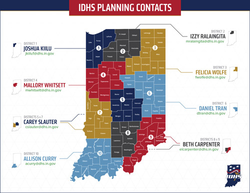
Map of Indiana counties with color-coded districts with numbers and people's contact info
Planning and Assessment Section Staff (select for contacts)

About the Planning and Assessment Section

The Planning and Assessment Section is a comprehensive section that assists the state government, local governments and the private sector plan prepare for and estimate all levels of outcomes for a disaster, natural or manmade.

This section develops, maintains and enhances more than 70 state-level emergency plans and ensures compliance with federal guidelines. This includes overseeing compliance with the National Incident Management System (NIMS). It also works at the local level and provides planning templates, guidance, review and feedback of emergency plans to counties and businesses.

The Planning and Assessment Section also collaborates with other IDHS sections to provide expertise to plans being validated by the Exercise Section, training data to the Training Section from responses collected from local county governments and businesses and more.

Map of Indiana counties with color-coded districts with numbers and people's contact info
Planning Section Staff (select for contacts)

Upcoming Events and Deadlines

View full IDHS calendar

Note: Not all events on the IDHS calendar are organized, hosted or sponsored by IDHS or other state agencies. Some events are included for informational purposes as events that the public or first responders may find beneficial.

The Planning and Assessment Section manages the reporting cycles for several assessments and surveys of emergency management agencies statewide:

Assessment or Survey Deadline (Frequency)
Hazard Identification and Risk Assessment (HIRA) January 30 (every three years: 2021-2024-2027)
Threat and Hazard Identification Risk Assessment (THIRA) October 31 (every three years: 2022-2025-2028)
Stakeholder Preparedness Review (SPR) October 31 (annually)
Special Event Assessment Rating (SEAR) August 26 (annually)
NIMS Compliance Survey November 15 (annually)
Comprehensive Preparedness Guide (CPG) 101 Compliance Survey November 15 (annually)

Functional Areas

The Planning and Assessment Section covers many areas of emergency preparedness, including the six components of NIMS: National Qualification System, resource typing, inventorying, mutual aid, Incident Command System and emergency operations centers. Learn more about the section's planning and risk assessment scope of work below.

Continuity, recovery and resilience planning ensures incorporation of strategies for maintaining continuity of operations and continuity of government, including identifying and prioritizing mission-essential functions and resources before, during and after incidents. Learn more about this area on the Continuity, Recovery and Resilience Planning page.

Continuity, recovery and resilience planning

Critical infrastructure and business emergency operations center planning covers plans for protecting assets in Indiana that are in the 16 critical infrastructure sectors as well as providing communications support for private-sector entities before, during and after disasters. Learn more about this area on the Critical Infrastructure and Business EOC Planning page.

Critical infrastructure and business EOC planning

Cybersecurity, risk assessment and compliance covers a wide range of plan development and maintenance. It assists counties with plans and reports, as well as coordinates with several partner agencies on ensuring cybersecurity concerns are being addressed in planning efforts. Learn more about this area on the Cybersecurity, Risk Assessment and Compliance page.

Cybersecurity, risk assessment and compliance planning

Emergency services planning covers plans for emergency operations, terrorism, communications, civil unrest and more, as well as lead planning and coordination for the emergency support functions of transportation, communications, firefighting, search and rescue, law enforcement and external affairs. Learn more about this area on the Emergency Services Planning page.

Emergency services planning

  • State Emergency Operations Plan (EOP) Support-Specific Plans:
    • ESF Annex 6: Mass Care
    • ESF Annex 7: Logistics
    • ESF Annex 8: Public Health and Medical Services
    • Volunteer and Donation Management
    • Mass Fatality, Casualty and Mortuary Response
    • State Repatriation Plan
    • State Host Plan
  • Mass Care Base Plan and Support Annexes, which include:
    • Shelter Management
    • Pet Sheltering
    • Temporary Housing
    • Access and Functional Needs
    • Disaster Mental Health
    • Family Assistance Center
    • Family Reunification Centers
  • State Logistics Plan and Support Annexes, which include:
    • Distribution Management
    • Logistics Staging Area
    • Commodities-Point of Distribution (C-POD)
    • Responder Reception Site and Base Camp
    • Emergency Management Assistance Compact (EMAC)
  • Crosswalk planning coordination with the Indiana Department of Health (IDOH), IDHS and supporting partners for all public health emergency response plans, including Pandemic Response and Strategic National Stockpile (SNS).
  • State Emergency Operations Plan (EOP) Support-Specific Plans:
    • ESF Annex 5: Information and Planning
    • ESF Annex 11: Agriculture and Natural Resources
  • Severe Weather Plan and Support Annexes, which include:
    • Flood
      • Flash Flood, Storm Surge, Seiche
    • Storm
      • Tornado, Lightning, Solar Flares
    • Extreme Weather
      • Heat Wave, Cold Wave, Blizzard, Derechos, Wildfire, Land Fire
    • Climate Change
    • Drought
  • Catastrophic Earthquake Base Plan and Support Annexes, which include:
    • Wabash Valley Seismic Zone (WBSZ)
    • New Madrid Seismic Zone (NMSZ)

Technological hazards planning covers plans for chemical, biological, radiological, nuclear and explosives risks. Learn more about this area on the Technological Hazards Planning page.

Technological hazards planning

Resources

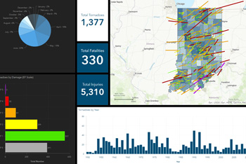
Dashboard excerpt with charts, map and numbers
Tornado History Viewer
Dashboard excerpt with charts, map and numbers
Tornado History Viewer

The Planning and Assessment Section works with a geospatial information systems (GIS) team that helps develop and maintain systems for agency and public use, such as the Tornado History ViewerTornado History Viewer, which is an interactive dashboard that provides details about the hundreds of verified tornadoes that have occurred in Indiana since 1950. Other projects include: