Location: NW corner SR 3 junction with Kinderhook Road (Section 296 Clark's Grant), 3 miles NW of Naab. Replaces 72.1967.1 (Scott County, Indiana)
Installed: 2002 Indiana Historical Bureau, Preservation Alliance, Inc., and Scott County Community Foundation
ID# : 72.2002.5
Text
Side one:
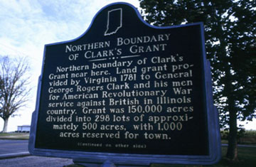
Northern boundary of Clark's Grant near here. Land grant provided by Virginia 1781 to General George Rogers Clark and his men for American Revolutionary War service against British in Illinois country. Grant was 150, 000 acres divided into 298 lots of approximately 500 acres, with 1, 000 acres reserved for town.
Side two:
Clarksville, first American settlement northwest of the Ohio River (1784), located at southwestern corner of grant. This marker (*) is located in Tract No. 296. [Map on side two with grant boundaries over current county boundaries.]
Keywords
Early Settlement and Exploration, Historic District, Neighborhoods, and Towns, Government Institutions
Annotated Text
Northern boundary of Clark's Grant near here. Land grant provided by Virginia 1781 to General George Rogers Clark and his men for American Revolutionary War service against British in Illinois country. Grant was 150, 000 acres divided into 298 lots of approximately 500 acres, with 1, 000 acres reserved for town.(1)
MAP ON SIDE TWO WITH GRANT BOUNDARIES OVER CURRENT COUNTY BOUNDARIES Clarksville, first American settlement northwest of the Ohio River (1784), located at southwestern corner of grant.(2) This marker (*) is located in Tract No. 296.(3)
Notes:
(1) William Hayden English, Conquest of the Country Northwest of the River Ohio, 1778-1783 and Life of Gen. George Rogers Clark (Indianapolis, 1896), 826-28, facsimile of Official Plat, 2:852-53; John D. Barnhart and Dorothy L. Riker, Indiana to 1816: The Colonial Period (Indianapolis, 1971), 252-54.
(2) English, 826-29; Barnhart and Riker, 254
(3) English, facsimile of Official Plat, 852-53