Buckingham's Base Line
Location: 5891 N. US 231, Jasper (Dubois County, Indiana) 47546
Installed 2018 Indiana Historical Bureau and the Dubois County Historical Society
ID#: 19.2018.1
This marker replaces the Buckingham’s Base Line marker (19.1966.1) installed in 1966.
![]() Visit the Indiana History Blog to learn how the survey system defined Indiana's landscape and furthered democracy for white settlers at the expense of the Wyandot, Delaware, Shawnee, Ottawa, Miami, Eel River, Wea, Chippewa, Potawatomi, Kickapoo, Piankashaw, and Kaskaskia people who first made this land home.
Visit the Indiana History Blog to learn how the survey system defined Indiana's landscape and furthered democracy for white settlers at the expense of the Wyandot, Delaware, Shawnee, Ottawa, Miami, Eel River, Wea, Chippewa, Potawatomi, Kickapoo, Piankashaw, and Kaskaskia people who first made this land home.
T ext
Side One:
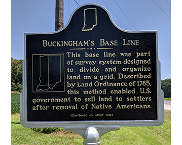
This base line was part of survey system designed to divide and organize land on a grid. Described by Land Ordinance of 1785, this method enabled U.S. government to sell land to settlers after removal of Native Americans.
Side Two:
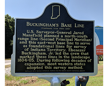
U.S. Surveyor-General Jared Mansfield planned a north-south range line (Second Principal Meridian) and this east-west base line to serve as foundational lines for survey of Indiana Territory. Ebenezer Buckingham, Jr. led the crew that marked these lines in the landscape 1804-05. During following decades of expansion, most western states adopted this survey method.
Annotated Text
Side One:
This base line was part of survey system designed to divide and organize land on a grid. [1] Described by Land Ordinance of 1785,[2] this method enabled US government to sell land to settlers after removal of Native Americans.[3]
Side Two:
U.S. Surveyor-General Jared Mansfield[4] planned a north-south range line (Second Principal Meridian) and this east-west base line to serve as foundational lines for survey of Indiana Territory.[5] Ebenezer Buckingham, Jr.[6] led the crew that marked these lines in the landscape 1804-5.[7] During following decades of expansion, most western states adopted this survey method.[8]
[1]George R. Wilson, Early Indiana Trails and Surveys (Indianapolis: Indiana Historical Society, 1919, reprinted 2002), 56, 66; Indiana Historical Bureau, “Indiana Territory,” The Indiana Historian (March 1999), 4, accessed in.gov/history; C. Albert White, A History of the Rectangular Survey System (Washington, D.C.: U.S. Bureau of Land Management, 1983), 11-29, accessed GoogleBooks; Michael P. Conzen, The Making of the American Landscape (New York and London: Routledge, 2010), 145-7.
Baselines are east-west lines, or parallels, which intersect with north-south meridian lines to create an initial point from which to measure land in a rectangular survey system. This baseline located at 38° 28’ 20” north latitude is known locally as Buckingham’s Base line for its surveyor, Ebenezer Buckingham. See footnote 2 for more information on the survey system and footnote 7 for more information on Ebenezer Buckingham.
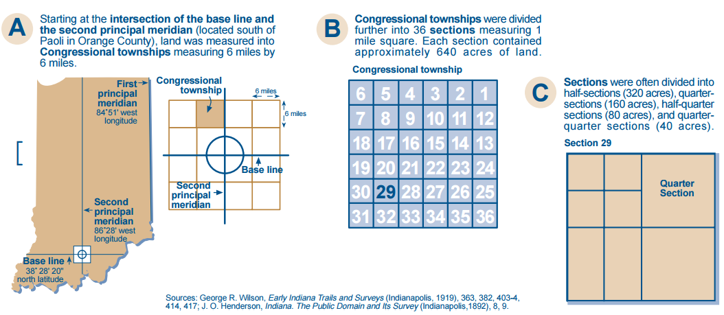
From the intersection of the base line and the meridian, surveyors then calculated lines every six miles to create squares called townships. Each township was then further divided into one mile squares creating thirty-six sections of land. Each section contained 640 acres of land which could then be divided further in half, quarter, half-quarter, and quarter-quarter sections as needed. For information on the establishment and significance of this system, see footnote 2. Diagram published by the Indiana Historical Bureau and cited above.
[2] “The Ordinance of 1784,” United States in Congress Assembled April 23, 1784, Founders Online, National Archives, accessed founders.archives.gov; “An Ordinance for Ascertaining the Mode of Disposing of Lands in the Western Territory,” Journals of the Continental Congress, Volume 28, May 20, 1785, A Century of Lawmaking, American Memory, Library of Congress, accessed memory.loc.gov; Thomas Jefferson to John Jay, August 23, 1785, Thomas Jefferson Papers, accessed National Archives Founders Online; Ted Steinberg, Down to Earth: Nature’s Role in American History (Oxford: Oxford University Press, 2000), 66-68; Hildegard Binder Johnson, “Gridding a National Landscape,” in Michael P. Conzen, ed., The Making of the American Landscape, (New York: Routledge, Taylor & Francis Group, 2010), 142-144; Matthew Dennis, “Cultures of Nature: To CA. 1810,” in A Companion to American Environmental History, Douglas Cazaux Sachman, ed, (John Wiley & Sons, Inc, 2010), 235. Diagram by Indiana Historical Bureau:
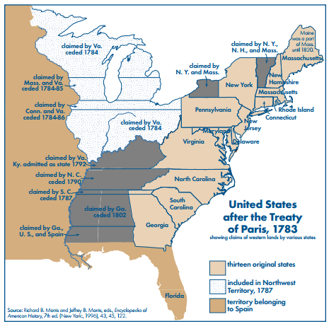
After the American Revolutionary War and via the 1783 Treaty of Paris, the British gave up claim to the thirteen colonies and ceded a vast amount of western and southern territory to the young United States. In order to grow the republic and repay war debt, the new government needed a system for organizing this land for sale. In response to these needs, the Continental Congress created a committee headed by Thomas Jefferson to create a system for surveying the new territory.
Jefferson passionately believed that the system had to make small plots of land available to the individual farmer (as opposed to large plots available only to the wealthy, to speculators, or to large companies) in order to spread democracy throughout the territory. In 1785, Jefferson wrote:
We have now lands enough to employ an infinite number of people in their cultivation. Cultivators of the earth are the most valuable citizens. They are the most vigorous, the most independent, the most virtuous, and they are tied to their country and wedded to it liberty and interests by the most lasing bands.
The committee’s answer was the Land Ordinance of 1784 which stated that the territory should be divided into ten-mile squares and organized by “lines to be run and marked due north and south, and others crossing at right angles.” Surveyors would mark these lines defining the squares, called townships, and subdivide these into smaller parcels which could be numbered and recorded for sale. In this manner, the landscape could be divided and sold to settlers without having to map the land in the old system of metes and bounds (which used natural markers like trees and rivers to define property). This was time consuming, required the surveyor’s physical presence in the landscape, and often led to land disputes. While the 1784 Ordinance did not become law, it did define the rectangular system and lay out the principles that would measure and divide the landscape into what it is today. On May 20, 1785, Congress passed the Land Ordinance of 1785, a revised version of the 1784 plan. It began:
Be it ordained by the United States in Congress assembled, that the territory ceded by individual States to the United States, which has been purchase of the Indian inhabitants, shall be disposed of in the following manner: A surveyor from each state shall be appointed by Congress, or a committee of States, who shall take an Oath for the faithful discharge of his duty, before the Geographer of the United States, who is hereby empowered and directed to administer the same; and the like oath shall be administered to each chain carrier, by the surveyor under whom he acts.
This ordinance reduced townships to the six-mile squares that became standard and laid out a detailed plan for surveying the territory using mathematics and standardized chains for measuring. The ordinance stated that surveying would begin on the Ohio, at a point that shall be found to be due north from the termination of a line which has been run as the southern boundary of the state of Pennsylvania.” According to historian Matthew Dennis, this rectangular survey system allowed the leaders of the young government to apply their “nationalistic, scientific, and engineering mentality in transforming the continental landscape of North America, reconceptualizing its space, subduing and organizing it, and distributing it to white yeoman farmers in the interest of national expansion, and, they believed, democracy.”
[3] Ibid.; “An Ordinance for the Government of the Territory of the United States, North-West of the River Ohio, 1787,” Confederation Congress, Adopted July 13, 1787, Rare Book and Special Collections Division, accessed Library of Congress; “A Treaty of Peace between the United States of America, and the Tribes of Indians called the Wyandots, Delawares, Shawanees, Ottawas, Chippewas, Pattawatimas, Miamis, Eel Rivers, Weas, Kickapoos, Piankeshaws, and Kaskaskias,” [Treaty of Greenville, 1795], Concluded August 3, 1795,in Charles J. Kappler, ed., Indian Affairs: Laws and Treaties, Vol. II (Washington, D.C.: Government Printing Office, 1904), accessed Lillian Goldman Law Library, Yale Law School, avalon.law.yale.edu; United States. “An Act Providing for the Sale of the Lands Northwest of the River Ohio,” May 18, 1796, The Territorial Papers of the United States, ed. Clarence Edwin Carter, Vol III: The Territory Northwest of the River Ohio, 1787-1803 (United States Government Printing Office, United States: 1934), 552-553, accessed HathiTrust; Thomas Jefferson to William Henry Harrison, 1803, in James Joseph Buss, Winning the West with Words: Language and Conquest in the Lower Great Lakes (Norman: University of Oklahoma Press, 2011), 15;
The removal of the Native American Indians living in the territories was the first step of the survey process and was declared in in both the proposed 1784 Land Ordinance and the adopted 1785 Land Ordinance. The United States government worked toward Indian removal through both military action and treaties in order to make space for white male settlers to farm the land. On July 13, 1787, Congress passed the Northwest Ordinance, an act which created the Northwest Territory (an area that would become the states of Ohio, Indiana, Illinois, Michigan, Wisconsin, and part of Minnesota) and provided a system for settling the area to create new states.
The U.S. government viewed conflict with American Indiana groups native to the area as the biggest obstacle to the expansion and settlement anticipated by the Northwest Ordinance. According to historian Eric Hemenway of the Little Traverse Bay Bands of Odawa Indians:
Between 1774 and 1794, Indian villages in New York, Pennsylvania, Indiana and Ohio were constantly attacked by the American army and militias. The Shawnee, Delaware, Iroquois, Miami, Odawa, Wyandot and Mingo saw unspeakable violence committed against their villages during this time period. Over 100 Indian villages were burned and destroyed, leaving an unknown number of civilian casualties.
The U.S. government applied military, economic, and diplomatic pressure on native peoples to cede land and create a peace, no matter how tenuous. After suffering major losses at the 1794 Battle of Fallen Timbers, many groups of American Indians native to the Northwest Territory were resigned to settling for peace. This resulted in the 1795 Treaty of Greenville, which ceded large sections of Native American land in Ohio and Indiana to the United States and opened much of the area to settlement. While the U.S. government offered payment in goods for signing the treaty, some Native American Indians became dependent on these annuities as the land on which they made their living was taken from them. In some cases, they went into debt and lost even more land as a result. This situation was often exploited by the United States government. For example, in 1803, President Thomas Jefferson wrote William Henry Harrison:
We shall push our trading houses, and be glad to see the good and influential individuals among [Great Lakes Indians] run in debt, because we observe that when these debts get beyond what the individuals can pay, they become willing to lop them off by a cession of lands.
After the Treaty of Greenville provided prospective settlers the security of peace with the Native American Indians, Congress passed the Land Act of 1796. This act provided for the sale of land in the Northwest Territory. It reiterated that surveys would be conducted in areas “in which the titles of the Indian tribes have been extinguished.” This appointed a Surveyor General directed to employ deputy surveyors and described the survey system much like the one explained by the Land Ordinance of 1785.
[4] Thomas Jefferson to the Senate, April 27, 1802, Jefferson Papers, National Archives, accessed Founders Online; Senate Executive Journal, First Session, Seventh Congress, May 3, 1802, page 424, Century of Lawmaking, accessed Library of Congress; Thomas Jefferson to Jared Mansfield, May 21, 1803, Gilder Lehrman Collection, accessed Founders Online; Thomas Jefferson to the Senate, November 11, 1803, Jefferson Papers, National Archives, accessed Founders Online; Senate Executive Journal, Second Session, Twelfth Congress, November 13, 1812, Century of Lawmaking, accessed Library of Congress; “Jared A. Mansfield,” United States Military Academy, West Point, Department of Mathematics, accessed USMA.edu; Joe Albree, “Jared Mansfield,” Mathematical Association of America, Ohio MAA, accessed sections.MAA.org/ohio.
Jared Mansfield (1759-1830) came to the attention of President Thomas Jefferson in 1801 upon the publication of his book Essays, Mathematical and Physical, one of the earliest works of original mathematics by an American. On May 3, 1802, the U.S. Senate approved the April 27 message from President Thomas Jefferson appointing Jared Mansfield Captain of the Corp of Engineers.
On May 21, 1803, Jefferson wrote to Mansfield expressing his disappointment with the current Surveyor General Rufus Putnam for his errors in “laying off the townships, not having been able to run parallel East & West Lines.” Jefferson was confident that Mansfield would do a better job: “I am happy in possessing satisfactory proof of your being entirely master of this subject, and therefore in proposing to you to undertake the office.” According to a November 5, 1803 letter from Mansfield to Jefferson, Mansfield had begun his work by September of that year. In November 1803 Jefferson reappointed Mansfield who served as Surveyor General until 1812. On November 13, 1812, the Senate approved a new Surveyor General after Mansfield’s resignation.
[5] “Indiana Territory,” February 1804, Annals of Congress, House of Representatives, 8th Congress, 1st Session, 1024, American Memory, Century of Lawmaking; Jared Mansfield to the Secretary of the Treasury, October 26, 1804, The Territorial Papers of the United States, Clarence Edwin Carter, ed, Vol. VII: The Territory of Indiana (United States Government Printing Office, Washington: 1939), 231-233, accessed HathiTrust; Wilson, 404; Bill Hubbard Jr., American Boundaries: The Nation, The States, The Rectangular Survey (Chicago: University of Chicago Press), 271-273; Lola Cazier, Surveys and Surveyors of the Public Domain, 1785-1975, (Washington, DC: US Government Printing Office, 1976) 47, accessed HathiTrust. Image from: “Roger Woodfill, Greenville & Grouseland Treaty Lines,” accessed Virtual Museum of Surveying. Click for larger image.
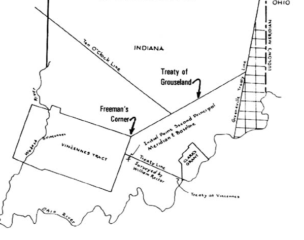
The land which would become Indiana was difficult to survey because much of it was still Indian territory and because of the Vincennes Tract, an area ceded by local Indians to French settlers in 1742. This area ran along the Wabash River and had been surveyed at an angle and titles sold to the French settlers. Since 1787, the inhabitants of the Vincennes Tract had been petitioning Congress to validate its titles. In May 1802, Congress determined that the territory should be surveyed by the rectangular method except where it had been previously surveyed. In other words, the Vincennes Tract would sit like an oddly angled puzzle piece within the rest of the rectangular pieces. The lines forming the rectangles would stop at the edge of the Vincennes Tract and then continue after it on all sides. According to survey historian Bill Hubbard, since the purpose of the rectangular survey was to organize the land for sale, there was no need to resurvey the tract.
Meanwhile, in March 1803, Ohio became a state, leaving the rest of the former Northwest Territory as the Indiana Territory, which Congress wanted surveyed in full in preparation for settlement. In June 1803, the Vincennes Tract’s boundaries were confirmed through Indian treaties and the edges surveyed. In July 1803, Jefferson named Jared Mansfield Surveyor General and thus surveying the Indiana Territory around the irregular tract became his challenge. U.S. government officials assumed it was a matter of time before the rest of the territory would be purchased from the Indians and thus Mansfield needed to develop a technique for surveying this vast landscape that did not include the time-consuming and even dangerous physical trek through the landscape measuring with steps and chains. Instead, he determined that he could create a meridian and a baseline ran off the corners of the Vincennes tract which would be the foundation of a new six-mile grid.
Mansfield planned a baseline that would start at the southwestern corner of the Vincennes Tract and run east-west to the edge of the territory and a meridian which ran from the southeastern edge of the tract north through the territory. The north-south line was called the Second Principal Meridian and coincides with 86° 28’ west longitude. The base line coincides with 38° 28’ 20” north latitude and became known locally as Buckingham’s Base Line (see footnotes 1 and 7). From the intersection of these lines, survey lines could be calculated every six miles in all four directions to create a grid of townships. (See footnote 1). Mansfield described his plan to the Secretary of the Treasury October 26, 1804:
I have assumed a meridian, which I conceived to be at a proper distance from the one, which forms the Western boundary at the State of Ohio…may be called, the 2d Meridian. One Meridian, viz. that which is the Western Boundary of the State of Ohio, would have been sufficient if surveys could have been made in regular progression from it Westward; But it would be impossible in this discontinued Tract, without more data.
Mansfield continued:
The Townships would not then, as heretofore, be numbered from the Ohio, but from the Base Line, which I have caused to run for the purpose of surveying here. This I account an advantage, as it would preserve an uniformity of numbers in the adjacent Townships of different ranges & the mind would at once derive from the general plan, a correct idea of their position, as well as the meanders of the River.[5]
[6] Rufus Putnam to the Secretary of the Treasury, January 9, 1799, in Clarence Edwin Carter, ed., Territorial Papers of the United States, Vol. III: Territory Northwest of the River Ohio, 1787-1803 (Washington, D.C.: United States Government Printing Office, 1934); “Internal Improvements,” Sandusky Clarion, May 1, 1822, 2, accessed Newspapers.com; Sandusky Clarion, December 24, 1823, 1, accessed Newspapers.com; “Electoral Ticket,” Sandusky Clarion, April 7, 1824, 2, Newspapers.com; Sandusky Clarion, August 29, 1832, 3; “An Act,” Sandusky Clarion, April 9, 1925, 2, Newspapers.com; James Buckingham, The Ancestors of Ebenezer Buckingham Who Was Born in 1748 and of His Descendants (Chicago: R. R. Donnelley & Sons Company, Printers, 1892), 23-29, accessed GoogleBooks; ; “Ebenezer Buckingham,” photograph of grave, Woodlawn Cemetery, Zanesville, Ohio, accessed findagrave.com; C. Albert White, A History of the Rectangular Survey System (Washington, D.C.: U.S. Bureau of Land Management, 1983), 37, accessed Google Books.
According to a published family history, Ebenezer Buckingham Jr. was born to Ebenezer and Esther Buckingham February 9, 1778, in Greenfield, Connecticut. His gravestone confirms these dates. Buckingham reportedly migrated to Ohio in 1796 and began working as a farmhand for Rufus Putnam, a general in the Revolutionary War, a farmer, and a surveyor. When President George Washington appointed Putnam as the country’s first Surveyor General in 1796, Buckingham assisted surveying trips in several Ohio counties. On January 9, 1799, Surveyor General Rufus Putnam sent Secretary of the Treasury Oliver Wolcott a copy of the “certificate of Buckingham’s being sworn as a deputy Surveyor.” In July of that year, Buckingham surveyed the western district of the territory (in what is now Ohio) north of the Seven Ranges and Military Tract and south of the Connecticut reserve.
In 1803 Jared Mansfield became surveyor general (see footnote 4) and planned a new meridian and baseline to create a rectangular survey of the Indiana Territory (see footnote 5). In 1804, Buckingham began running the base line planned by Mansfield (see footnote 7). By 1810, he was running a store in Marietta, Ohio and continued as a businessman for the rest of his life. In his later years, Buckingham became important to the state of Ohio as a leader of internal improvements and as a state senator.
[7] “A Bill Making Provision for the Disposal of the Public Lands in the Indiana Territory, and for Other Purposes,” March 5, 1804, Bills and Resolutions, House of Representatives, 8th Congress, 1st Session, Bill 70, accessedAmerican Memory, Library of Congress; “A Bill Supplementary to the Act, Intitled [sic] ‘An Act Making Provision for the Disposal of the Public Lands in the Indiana Territory, and for Other Purposes,” February 8, 1805, Bills and Resolutions, House of Representatives, 8th Congress, 2nd Session, Bill 137, accessed American Memory, Century of Lawmaking; George R. Wilson, Early Indiana Trails and Surveys (Indianapolis: C.E. Pauley & Co, 1919), 414-418; Hubbard, American Boundaries, 271-273; Hubbard 273. Wilson cites Buckingham’s original field notes which are located in an unprocessed collection at Indiana Archives and Records Administration. Image: Hubbard, 272, cited above.
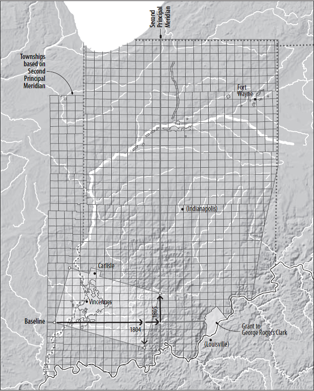
While Mansfield calculated the base line, it still had to be physically measured and marked in the landscape. In 1804, Mansfield appointed Ebenezer Buckingham to lead a crew to run the base line. They began at a point on the south-side of the Vincennes Tract and ran a line east for 67.5 miles, marking off miles and half-miles on trees. Buckingham and crew then went to the southeast corner of the Vincennes Tract and ran a line due north until they reached the baseline. When they intersected the baseline, they marked the initial point. Then, they marked section corners and half-section corners until they reached the east end of the Vincennes Tract again. They packed up for the winter and returned the next season to finish extending the baseline east twelve miles and the meridian north in September 1805. The placement of the baseline and meridian in these locations allowed Buckingham and his crew to lay the foundations for the survey system and include the Vincennes Tract in it, all without encroaching on lands that still belonged to Native Americans. After this, the townships could be numbered and the land further divided. The township numbers would be increased east and west away from the Principal Meridian and be numbered away from the Baseline north and south, starting at the Initial Point where the two lines crossed.
[8] Conzen, 143; Joe Albree, “Jared Mansfield,” Mathematical Association of America, Ohio MAA, accessed sections.MAA.org/ohio. Image: Conzen, 143, cited above.
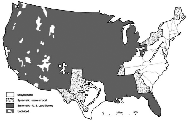
According to historian Michael P. Conzen, “Except for the original 13 colonies, Texas, and some western mountainous areas, most of the country is parceled out on the township and range system.” The methods perfected by Mansfield (see footnote 4) were applied throughout this vast area. According to Auburn University mathematics professor Joe Albree: “In [his survey of Indiana Territory] and in his subsequent work Mansfield faithfully followed the basic principles of scientific surveying – the principles upon which the lands were surveyed across the country as the nation expanded through the rest of the nineteenth century.”
Keywords
Early Settlement & Exploration; American Indian