Surveying possible routes for a canal was often the first step in deciding whether a canal could be built. Some surveys never resulted in canals, generally because of a lack of funding. The map on page 3 of the June issue of The Indiana Historian provides some examples of proposed canals.
Before any construction could begin, however, the route for a canal had to be precisely determined by surveying. Indiana's canals followed the course of rivers, which provided the needed source of water. Survey teams lived in tents, moving their camps as they methodically made their way down the river. Conditions for canal survey work in the early 1800s could be primitive at best. Much of Indiana was wilderness.
The diary of John Peter Paul excerpted here documents his work surveying for Indiana's Wabash and Erie Canal in 1827. His experience is probably typical of the men who helped to make canals a reality.
Pre-1855 surveying techniques are fairly similar to modern practices. Modern instruments are far more precise. The object is the same--to determine by measurement the boundaries of a particular piece of land or the course of a transportation route.
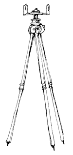
Early surveyors' instruments included four basic pieces as indicated in the drawings.
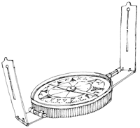
The surveyor's compass (1) was used to tell direction and locate a straight line between two points. The compass was mounted on a tripod (2) to steady it. Levels (1a) on the compass assured it was level on the tripod.
The surveyor's assistant, called a rodman or poleman, used a pole (3) about ten feet in length, held upright at a distant point from the surveyor and his compass. The surveyor then looked through the sights (1b) of the compass to the tip of the pole to establish a straight line.
![]()
A Gunter's chain (4), named after its inventor, English mathematician Edmund Gunter, was used to measure distances. The chain was made up of 100 iron or steel links. When uneven ground prevented accurate measurement, the surveyor used geometry to correct his measurements.
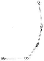
Common measures used by surveyors
1 link = 7.92 inches100 links =1 chain
1 chain = 66 feet
1 rod = 16.5 feet
80 chains = 1 mile
Drawings adapted from George Rogers Clark Teaching Unit (Indiana Department of Education, 1979), 35.