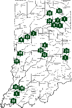
This map indicates one way Indiana's canal history is being preserved and made available to the public: through state format historic markers. There are additional canal markers throughout the state placed by communities and organizations.
The list of state markers on the map is keyed by the initial number; the name, county, and Historical Bureau identification number follow. The Historical Bureau's marker database is available on the internet.
- Wabash and Erie Canal Groundbreaking, Allen, 02.1992.2
- Wabash and Erie Canal, Carroll, 08.1992.1
- The Whitewater Canal, Fayette, 21.1966.1
- Attica & Covington Canal Skirmish, Fountain, 23.1997.1
- Wabash and Erie Canal Completed 1853, Gibson, 26.1976.1
- The Central Canal, Hamilton, 29.1994.1
- Forks of Wabash, Huntington, 35.1972.1
- Canal Landing on Washington Street/Jefferson Park Mall, Huntington, 35.1973.1
- Wabash & Erie Canal Lock 4, Huntington, 35.1997.1
- Papakeechie's Reserve, Kosciusko, 43.1962.1
- Central Canal, Marion, 49.1966.2
- Site of the Central Canal, Marion, 49.1992.5
- Sylvan Lake, Noble, 57.1992.1
- Wabash & Erie Canal, Parke, 61.1966.1
- Wabash and Erie Canal, Pike, 63.1966.2
- Wabash and Erie Canal, Pike, 63.1992.1
- The Wabash River, Tippecanoe, 79.1973.1
- Wabash and Erie Canal, Vanderburgh, 82.1947.1
- Terre Haute, Vigo, 84.1947.3
- Paradise Spring Treaty Ground, Wabash, 85.1992.1
- Cambridge City, Wayne, 89.1992.2