Baseflow is the groundwater contribution to streamflow. Baseflow in Indiana is easy to conceptualize as some streams continue to flow for days or even weeks after the last rainfall event. The reason the streams continue to flow is that groundwater is seeping into the streambed. The amount of baseflow is not even across the state and depends on natural and anthropogenic factors such as climate, soil type, topography, landscape, depth to bedrock, land use, water withdrawals, and water treatment plant discharge, etc. Baseflow is difficult to visualize because groundwater seeps into a stream through the small pore spaces in sand, gravel, silt, and clay. Indeed, one would not be able to discern groundwater seeps even if standing along a stream gazing into clear water. The U.S. Geological Survey (USGS) has conducted studies utilizing methods such as seepage meters installed in a stream and thermal infrared sensors showing how difficult it is to identify and quantify groundwater seepage into streams. A thermal infrared sensor can be used to identify groundwater seeps because of the temperature difference between groundwater and surface water. Some significant underground bedrock springs have been identified in Indiana mainly associated with the large swath of limestone bedrock at or near the surface in the south-central part of the state. For instance, the Lost River watershed is famous for its convoluted drainage system. Overall, groundwater is a significant component of streamflow in Indiana although quite variable throughout the state.
Streamflow can be thought of as originating from two components then; surface runoff and groundwater runoff. Surface runoff consists of precipitation falling directly onto a stream, and more significantly all of the water flowing into the stream from overland flow. Precipitation recharges groundwater through infiltration into the soil. If the soil becomes saturated, downward percolation continues into the saturated zone or an aquifer, with shallow groundwater from the aquifer subsequently discharging into a stream in places.
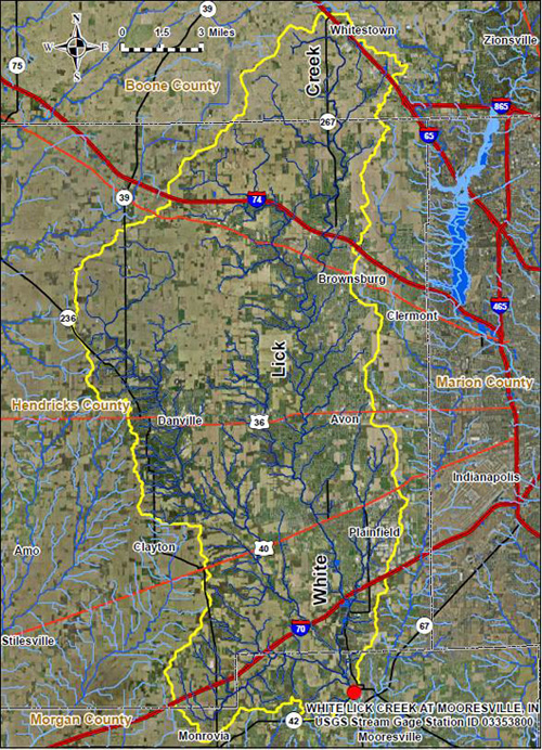
Surface runoff is constrained by a stream’s drainage divide (see the following image with the stream’s drainage basin divide or watershed outlined in yellow). Indeed, surface runoff can be separated from groundwater runoff by a technique called hydrograph separation. In fact, it has been demonstrated that surface runoff will end some fixed time after the peak of a storm. This can be readily visualized in a conceptual sense for Indiana as streams can continue to flow for days or even weeks after the last rainfall event. The streamflow is being sustained by groundwater seeping into the stream bed. Continuous streamflow gages are needed to perform the hydrograph separation calculations. Two mathematical models developed by the USGS are used in this study to account for some variation in baseflow estimates. The USGS Groundwater Toolbox (see http://water.usgs.gov/ogw/gwtoolbox/) is freely available to the public and contains the two programs utilized; HYSEP and PART. Three different hydrograph separation methods can be chosen with HYSEP. These are fixed interval, sliding interval, and local minimum. The local minimum method was selected because it generally gives baseflow values somewhat less (more conservative) than the other two methods.

The PART program distinguishes local minima on the hydrograph with a somewhat different algorithm from that in HYSEP. Results for PART typically exceed results calculated by HYSEP. For instance, the figure above outlines the drainage basin (in yellow) for the USGS stream gage White Lick Creek at Mooresville located in central Indiana.
The programs calculated baseflow for 694 months for the time period of January 1958 through October 2015. The baseflow calculated by PART exceeded the baseflow calculated by HYSEP for 581 of the 694 months, or 84 percent of the time. The PART average monthly baseflow for that time period was 61 percent while the HYSEP average was 56 percent. The monthly and annual streamflow and baseflow calculations for the White Lick Creek at Mooresville stream gage and watershed are in two spreadsheet files. These files are in a zip file that can be viewed or downloaded here WhiteLickCreekatMooresville.zip.
Baseflow studies can help intuitively and quantitatively understand the groundwater-surface water connection for watersheds. Water management strategies can be developed for water supply, water quality, navigation, thermoelectric and hydroelectric power, recreation, and ecology. For example, during the drought of 2012 very little precipitation occurred within the watershed for the month of July (about 0.3 inch; normal is about 4.5 inches). An average July 2012 monthly streamflow of 8.9 cubic feet per second (cfs) was estimated for the streamflow gage whereas the mean monthly streamflow for July is normally about 115 cfs. For July of 2012, PART calculated a baseflow of 91.5 percent while HYSEP calculated a baseflow of 90.8 percent. Drought thus presents a plethora of streamflow issues for aquatic habitat, waste assimilation, water withdrawals, and recreation. Understanding baseflow can help water resource managers study, comprehend, and prepare for environmental changes. It should be noted that the baseflow calculations are only an estimate. For instance, variables such as water withdrawals and waste water treatment plant discharges are not taken into account. In addition, streamflow gages can have a range of error of plus or minus six percent.
