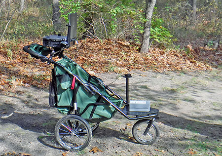
HETAP/WISP Trail Assessment Equipment.
The High Efficiency Trail Assessment Process, or HETAP, is an inventory process that provides objective information about trail conditions. The information obtained through these assessments can be used by land managers to enhance the safety and enjoyment for all trail users by providing accurate, objective information about trail conditions. It also allows land managers to monitor and address environmental impacts on trails, identify potential access barriers (e.g. difficult terrain), map trail systems, and improve or create existing parks or management plans.
This process is executed with the use of a specialized pushcart, which has measurement sensors and input operations that collect data like GPS coordinates, grade, slope, width, and trail type. The HETAP system also takes digital photographs of trail features and allows the user to mark special features throughout the trail system. As the process does not rely on hand-held tools, it is a more efficient method of data collection in terms of time and effort. It is a comprehensive and methodical process, the result of which is an objective and consistent dataset.
The data collected using the HETAP system is not only useful for land managers to monitor, evaluate, and enhance their properties, but it also provides an opportunity to inform trail users through universal signage. While there may be immutable factors that will affect a trail or a property’s accessibility, Trail Access Information (TAI) signage shares important data in a format that allows all users to make educated decisions about the properties they seek to access.
The HETAP equipment is available for loan from the Lake Michigan Coastal Program (LMCP) to Indiana coastal land managers by request. The LMCP can also provide technical and financial assistance to conduct trail assessments, create or update parks or management plans, or create signage in the Coastal Program Area.
Please contact coastal@dnr.IN.gov for more information.

