The Township Trustee is a vital resource for the community, providing direct assistance and support to residents in need. They help individuals facing financial hardship by offering emergency aid for necessities like food, shelter, and utilities. The Trustee also ensures access to essential services such as fire protection, cemetery upkeep, and community programs. As a local point of contact, they connect residents with additional resources and work to address community concerns, making local government more accessible and responsive to the needs of the people they serve.
| Township Trustees | Contact | Township |
| Mark Meyer | 502-376-9770 | Bethlehem |
| Barbara Reynolds | 502-649-9608 | Carr |
| Tom Kendrick | 502-544-0110 | Charlestown |
| Dale Popp | 812-989-6340 | Jeffersonville |
| Bradley Jones | Bdj9320@yahoo.com | Monroe |
| Chad Whitmer | 502-592-7138 | Oregon |
| Brittany Jones Kinder | 502-645-3032 | Owen |
| Bill Ramser | 502-419-8033 | Silver Creek |
| Greg Alexander | 812-786-5617 | Union |
| Robin Durbin | 502-533-0001 | Utica |
| Todd Webb | 812-406-5429 | Washington |
| Renie Coffman | 812-923-8970 | Wood |
Clark County Townships
Clark County is divided into twelve Townships. The county has a total area of 376.45 square miles (975.0 km2), of which 372.86 square miles (965.7 km2) (or 99.05%) is land and 3.60 square miles (9.3 km2) (or 0.96%) is water.
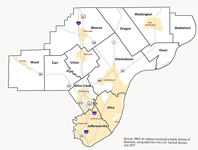
BETHLEHEM TOWNSHIP
Bethlehem township is located in the top right corner of Clark County. As of the 2010 census, its population was 309 and it contained 127 housing units. According to the 2010 census, the township has a total area of 18.59 square miles (48.1 km2), of which 18.27 square miles (47.3 km2) (or 98.28%) is land and 0.31 square miles (0.80 km2) (or 1.67%) is water. Towns include Bethlehem, Otto, and Miles Point.
CARR TOWNSHIP
Carr township is located in the west-central portion of Clark County. As of the 2010 census, its population was 3,452 and it contained 1,378 housing units. The township has a total area of 26.89 square miles (69.6 km2), of which 26.36 square miles (68.3 km2) (or 98.03%) is land and 0.53 square miles (1.4 km2) (or 1.97%) is water. Towns include Bennettsville, Broom Hill, Carwood, and Wilson.
CHARLESTOWN TOWNSHIP
Charlestown Township is located in the central portion of Clark County. As of the 2010 census, its population was 13,450 and it contained 5,382 housing units. The township has a total area of 65.09 square miles (168.6 km2), of which 64.49 square miles (167.0 km2) (or 99.08%) is land and 0.6 square miles (1.6 km2) (or 0.92%) is water. Towns and adjacent communities include Charlestown, Otisco, and Rolling Hills.
JEFFERSONVILLE TOWNSHIP
Jeffersonville township is located in the south portion of Clark County. As of the 2010 census, its population was 59,062 and it contained 27,023 housing units. The township has a total area of 26.88 square miles (69.6 km2), of which 26.57 square miles (68.8 km2) (or 98.85%) is land and 0.31 square miles (0.80 km2) (or 1.15%) is water. Brick House Pond and Silver Lakes are in this township. Cities and towns include Clarksville, Cementville, Jeffersonville, and Oak Park.
MONROE TOWNSHIP
Monroe township is located in the north-central portion of Clark County. As of the 2010 census, its population was 5,402 and it contained 2,125 housing units. The township has a total area of 56.06 square miles (145.2 km2), of which 55.78 square miles (144.5 km2) (or 99.50%) is land and 0.28 square miles (0.73 km2) (or 0.50%) is water. Towns include Blue Lick, Henryville, and Underwood.
OREGON TOWNSHIP
Oregon township is located in the north-central portion of Clark County. As of the 2010 census, its population was 1,769 and it contained 692 housing units. The township has a total area of 31.27 square miles (81.0 km2), of which 31.08 square miles (80.5 km2) (or 99.39%) is land and 0.19 square miles (0.49 km2) (or 0.61%) is water. Towns include Marysville and Runyantown.
OWEN TOWNSHIP
Owen township is located in the eastern portion of Clark County. As of the 2010 census, its population was 958 and it contained 462 housing units. The township has a total area of 17.35 square miles (44.9 km2), of which 17.07 square miles (44.2 km2) (or 98.39%) is land and 0.28 square miles (0.73 km2) (or 1.61%) is water. Towns include Hibernia, Owen, Sunset Village, and Vesta.
SILVER CREEK TOWNSHIP
Silver Creek township is located in the southern portion of Clark County. As of the 2010 census, its population was 11,858 and it contained 4,858 housing units. The township has a total area of 16.98 square miles (44.0 km2), of which 16.72 square miles (43.3 km2) (or 98.47%) is land and 0.27 square miles (0.70 km2) (or 1.59%) is water. Cities and Towns include Clarksville and Sellersburg.
UNION TOWNSHIP
Union township is located in the central portion of Clark County. As of the 2010 census, its population was 3,507 and it contained 1,415 housing units. The township has a total area of 21.08 square miles (54.6 km2), of which 20.85 square miles (54.0 km2) (or 98.91%) is land and 0.23 square miles (0.60 km2) (or 1.09%) is water. Towns include Memphis and Perry Crossing.
UTICA TOWNSHIP
Utica township is located in the central portion of Clark County. As of the 2010 census, its population was 6,016 and it contained 2,422 housing units. The township has a total area of 22.01 square miles (57.0 km2), of which 21.64 square miles (56.0 km2) (or 98.32%) is land and 0.36 square miles (0.93 km2) (or 1.64%) is water. Cities and towns include Jeffersonville and Utica.
WASHINGTON TOWNSHIP
Washington township is located in the central portion of Clark County. As of the 2010 census, its population was 1,702 and it contained 744 housing units. The township has a total area of 35.29 square miles (91.4 km2), of which 35.19 square miles (91.1 km2) (or 99.72%) is land and 0.09 square miles (0.23 km2) (or 0.26%) is water. Towns include New Washington and Nabb.
WOOD TOWNSHIP
Wood township is located in the central portion of Clark County. As of the 2010 census, its population was 2,747 and it contained 1,148 housing units. The township has a total area of 38.97 square miles (100.9 km2), of which 38.83 square miles (100.6 km2) (or 99.64%) is land and 0.13 square miles (0.34 km2) (or 0.33%) is water. Towns include Borden, Starlight, and Chestnut Hill.