Indiana's Northern Boundary Line
Location: 4.7 miles east of Fremont at 775 E & SR 120, Clear Lake south shore area. Replaces 76.1966.1 (Steuben County, Indiana)
Installed: 2000 Indiana Historical Bureau and with donations In Memory of John R. Stanley.
ID# : 76.2000.1
Text
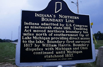
Side one:
Indiana admitted by U.S. Congress as nineteenth state 1816. Enabling Act moved northern boundary ten miles north of southernmost tip of Lake Michigan providing direct access to the lake. Boundary first surveyed 1817 by William Harris. Boundary disputes with Michigan and Ohio continued until Michigan statehood 1837.
Side two:
[map]
Enabling Act of 1816 established Indiana's northern boundary (3 miles north of here) as a line "drawn through a point ten miles north of the southern extreme of Lake Michigan."
Keywords
Early Settlement and Exploration, Government Institutions